You may have seen in the news that the probability of a Nankai Trough Earthquake has increased from 70%-80% to about 80%. But where is the Nankai Trough, and what does this change in probability mean?
In this article, we will explain the location of the Nankai Trough, what these numbers mean, and why preparing for such an event matters. Keep reading to learn more about this update and what it means for your safety.
If you would like to learn how to prepare for an earthquake, please see the information below.
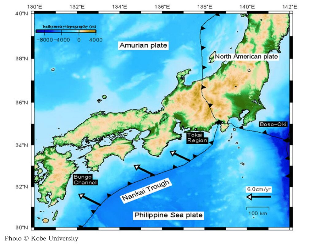
The Nankai Trough runs from Suruga Bay in Shizuoka Prefecture to the Hyuganada Sea off Miyazaki Prefecture. Japan sits on four tectonic plates: the North American, Amurian, Philippine Sea, and Pacific Plates. The trough is a trench formed as the Philippine Sea Plate slides under the Amurian Plate. It is a long stretch that spans from Kyushu to the Kanto region, making it a significant area to monitor for earthquakes.
A Nankai Trough Earthquake happens along the Nankai Trough, which stretches from Suruga Bay to the Hyuganada Sea off Miyazaki Prefecture. In this area:
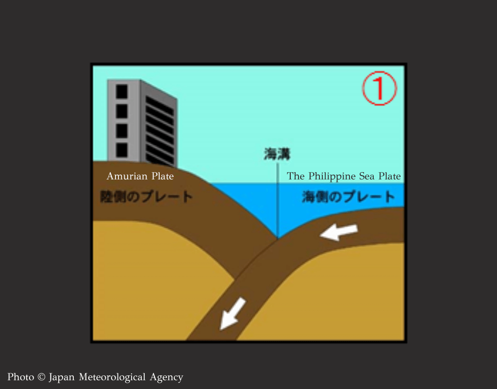
The Philippine Sea Plate slides under the Amurian Plate at a speed of a few centimeters per year.
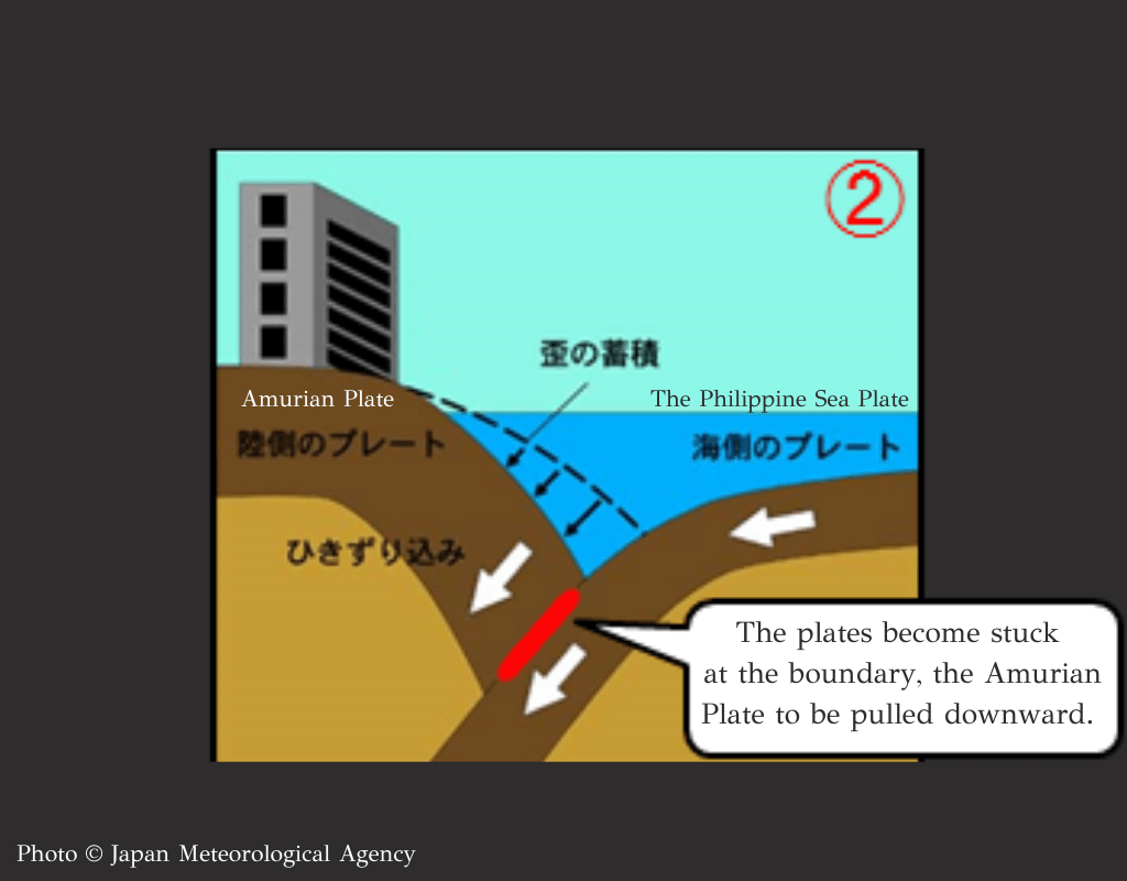
The plates become stuck at the boundary, causing the Amurian Plate to be pulled downward and build up strain.
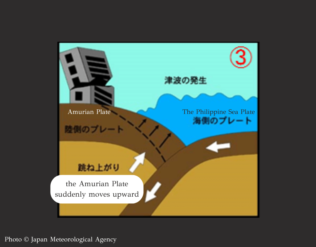
When the strain becomes too much, the Amurian Plate suddenly moves upward, causing an earthquake.
This process repeats, leading to repeated Nankai Trough Earthquakes.
Chapter 3: Why is a Nankai Trough Earthquake considered to be approaching?
Along the Nankai Trough, plates are constantly moving and building up strain. Historical records show that large earthquakes and tsunamis happen roughly every 100 to 150 years. Here are some past examples of Nankai Trough Earthquakes:
Past Earthquakes
1707 Hōei Earthquake: A massive earthquake with a magnitude of 8.6 struck from Enshū-nada to Shikoku on October 28, 1707.
Ansei-Tōkai and Ansei-Nankai Earthquakes (1854): On December 23, 1854, the Ansei-Tōkai Earthquake (M8.0) hit from the southeastern Kii Peninsula to Suruga Bay. About 31 hours later, the Ansei-Nankai Earthquake (M8.0) struck off the Kii Strait to Shikoku. These earthquakes caused widespread damage, including thousands of deaths and over 30,000 destroyed homes. Tsunami waves exceeded 20 meters in height in Mie and Kochi Prefectures.
Shōwa-Tōnankai Earthquake (1944): On December 7, 1944, an earthquake (M7.9) hit Shizuoka and Mie Prefectures. The tsunami reached up to 8 meters high in Mie, causing 1,223 deaths or disappearances, 2,864 injuries, and damaging over 95,000 homes.
Shōwa-Nankai Earthquake (1946): On December 21, 1946, this earthquake (M8.0) struck off the southern coast of Wakayama Prefecture. It caused shaking across a large area from the Tokai to Kyushu regions.
High Risk of Nankai Trough Earthquake in the Next 30 Years
Around 80 years have passed since these events, and there is a 70% to 80% chance of a Nankai Trough Earthquake happening in the next 30 years (as of May 2024), which makes it a high-priority concern.
Chapter 4: What Does the Increased Probability of 80% Mean?
On January 1, the government’s Earthquake Research Committee updated the probability of a Nankai Trough Earthquake happening in the next 30 years. They raised it from “70-80%” to “around 80%.” Naoto Hirata, the committee chairman, explained that the increase doesn’t mean the chance went up by 10%. Instead, it shows that as time passes without the earthquake happening, the likelihood of it occurring grows. Nankai Trough Earthquakes are considered easier to predict, but with many active faults in Japan, earthquakes can happen at any time. It’s important to keep preparing and practice evacuation plans with family and friends.